
When the Nation Draws the "Underground Blueprint," What Can GridWorld Do?
2026-01-14Preface
Recently, experts in the field of natural resources have called for the comprehensive development of multi-dimensional underground space resource surveys during the "15th Five-Year Plan" period and the construction of a nationally unified underground "One Map." The advancement of this national strategy not only concerns national territorial security and resource security but also charts an inevitable path toward the digitization and transparency of underground space. As a core promoter of 3D geological modeling and transparent earth technology in China, GridWorld's product matrix is providing key technological components and a solid data foundation for this grand "Underground Blueprint."
Core Engine: Independent 3D Geological Modeling Software
To build an "integrated above-ground and underground" 3D model, the primary step is to transform massive, heterogeneous geological data into high-precision, analyzable digital entities. GridWorld's independently developed series of 3D geological modeling software serves as the "core engine" for this process.
Multi-Source Data Integration
The software efficiently integrates multi-source data such as geological maps, boreholes, geophysical interpretations, and remote sensing data, addressing the challenge of "fragmented" underground information.
Full-Process Modeling
From geological interpretation and structural modeling to property model construction, it provides a complete, professional toolchain that meets the refined modeling needs from regional scales to engineering scales.
Openness and Compatibility
The standardized 3D models generated can seamlessly connect with GIS platforms, BIM design software, and professional analysis tools, making them an ideal data source for building the "One Map."
Scenario Empowerment: Professional Solutions for Key Sectors
In response to the four key survey priorities mentioned in the article, GridWorld has developed mature, targeted products and solutions.
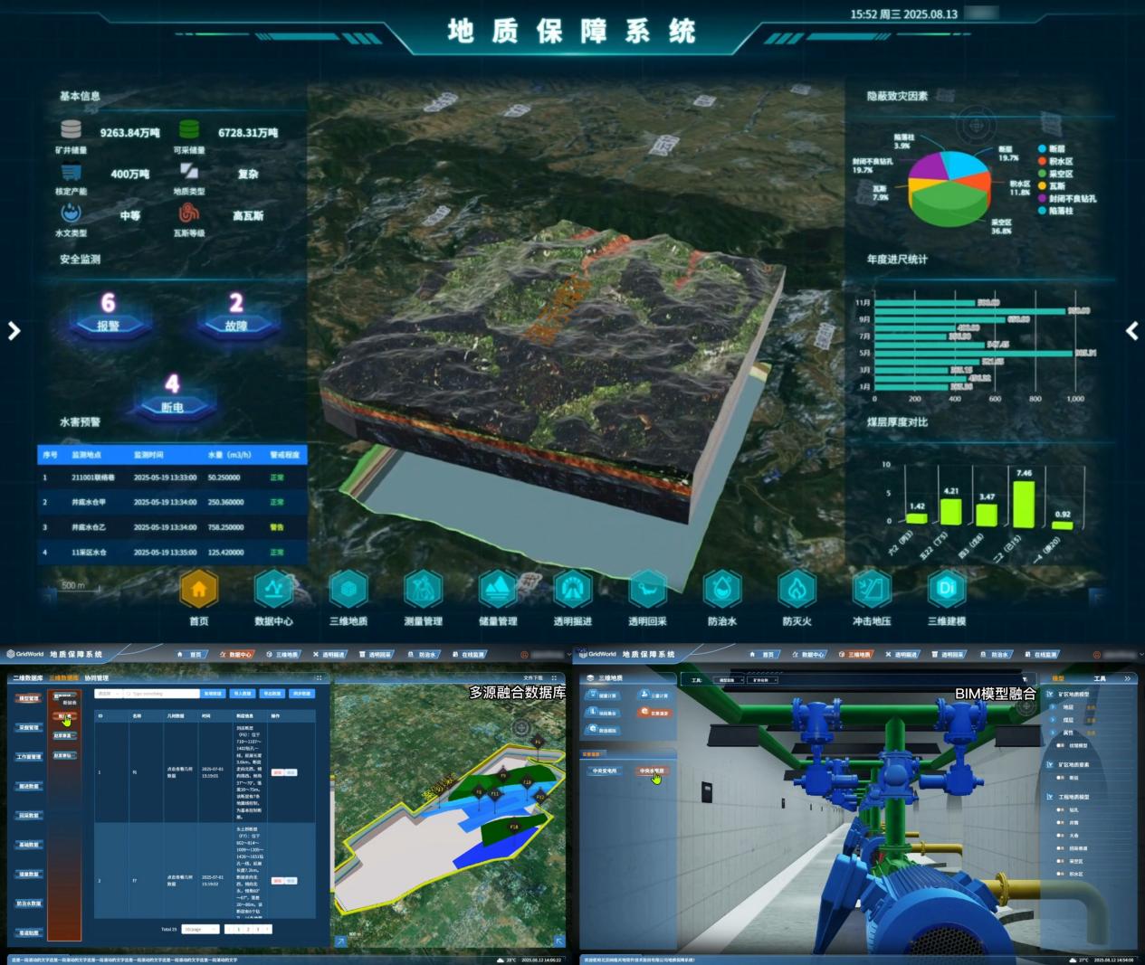
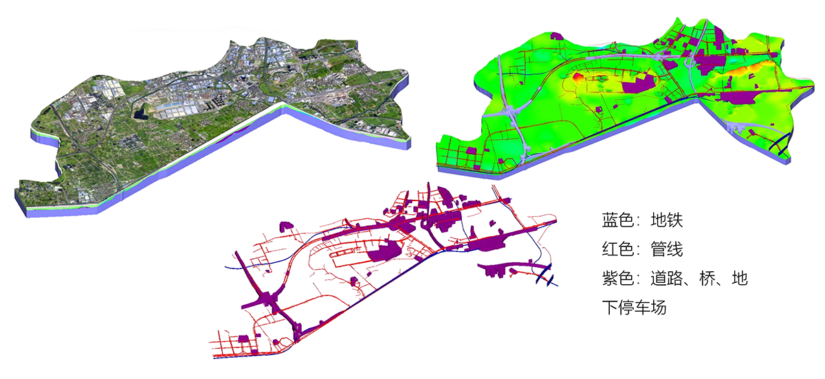
Supporting Urban Underground Space Safety
Our technology can establish integrated "geology-structure" models for projects such as subway tunnels, utility tunnels, and deep excavation pits, enabling visual assessment and simulation analysis of construction risks. This provides quantitative support for the scientific planning and safe operation of urban underground spaces.
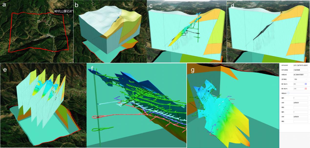
Serving Accurate Mineral Resource Exploration
The software platform offers powerful professional modules for "ore body modeling and resource reserve estimation," assisting geological exploration units in achieving 3D transparent prediction and evaluation of scarce strategic minerals, thereby improving exploration efficiency and resource security.
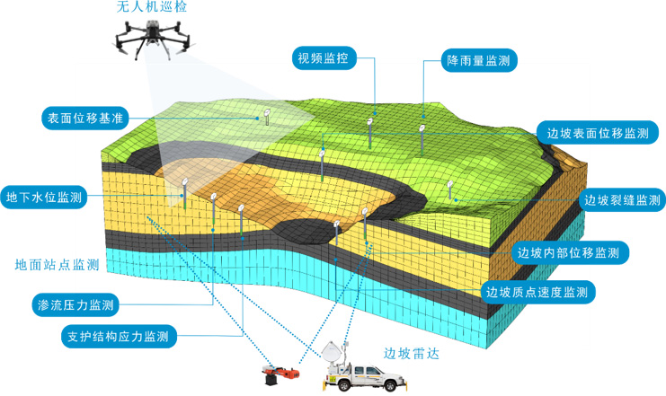
Assisting Geological Hazard Prevention and Control
By constructing dynamic 3D models incorporating geological structures, groundwater movement, and stress field coupling, our solutions support simulations of land subsidence evolution, risk analysis of water inrushes and mud outbursts, and provide critical decision-making support for geological disaster early warning and prevention.
Platform Hub: Building a Unified "Underground Data Foundation"
A true "One Map" relies on unified data management, dynamic updates, and collaborative application. GridWorld's Transparent Earth Digital Platform aims to play the role of both a "data foundation" and an "application middleware."
Data Aggregation and Governance
It enables centralized management, version control, and visual sharing of multi-scale, multi-period 3D geological models.
Model Lightweighting and Publishing
It supports converting professional geological models into lightweight formats suitable for online browsing and querying, lowering the barrier to use and facilitating cross-departmental collaboration.
Professional Application Integration
It provides standard interfaces for integrating specialized algorithms such as hydrological simulation and stability analysis, empowering deep applications in vertical scenarios like smart cities and the energy and mining industries.
Building a Transparent Earth Together, Serving National Strategy
GridWorld's product system covers the entire chain from data collection and model construction to smart applications, equipping us with the capability and responsibility to serve as a reliable technological partner for the national underground space resource survey. We look forward to collaborating with all stakeholders to transform digital technology into a powerful tool for understanding the nation's underground resources, promoting their knowability, manageability, and usability, and contributing industrial strength to safeguarding national resource security and enhancing territorial space governance.
Driving innovation through technology to serve the construction of a transparent China, ensuring every inch of the land is clearly visible in the digital world.