
Efficient Tetrahedral Mesh Export: Empowering the Entire Workflow of Engineering Geological Numerical Simulation
2026-08-05In the field of engineering geological numerical simulation, refined mesh modeling, cross-software data interoperability, and high-precision simulation analysis are key to ensuring reliable outcomes for geotechnical engineering, geological structure research, and fault mechanics analysis. In traditional numerical simulation workflows, issues such as cumbersome geological mesh reconstruction, poor cross-platform data compatibility, model import distortion, and insufficient accuracy in fault and strata simulation have long constrained both the efficiency of simulation analysis and the precision of engineering calculations. Focusing on these pain points, DepthInsight has developed core capabilities for one-click tetrahedral mesh export and seamless integration with Abaqus. This comprehensively optimizes the numerical simulation workflow, enhancing both quality and efficiency for various engineering geological simulations.
01) Precise Mesh Discretization for Complex Geological Simulation Scenarios
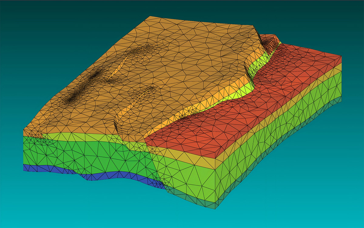
Geological structures are inherently complex and irregular. Conventional meshing methods often struggle to accommodate specific scenarios such as stratified layers, fault structures, and curved terrains, easily leading to mesh distortion and model inaccuracy, which directly affects the reliability of Abaqus numerical simulation results. DepthInsight features professional and mature tetrahedral mesh discretization capabilities, optimized specifically for core engineering geological modeling scenarios. It supports two mainstream modeling input methods to flexibly adapt to different project requirements.
The software supports both .brep model input and truncated grid input modes, while also accommodating meshing schemes with or without cross-section splitting. Users can freely switch between these options based on the complexity of the geological model and the required precision of the simulation analysis. Whether dealing with regular stratified block models or complex geological structures containing faults and folds, the software delivers high-quality tetrahedral meshing. With high element uniformity and standardized topology, it fully aligns with Abaqus finite element analysis standards, effectively reducing issues like calculation non-convergence and data deviations caused by mesh defects at the source.
02) Seamless Data Integration: Breaking Down Cross-Software Simulation Barriers
In traditional simulation workflows, data transmission gaps often exist between geological modeling software and Abaqus. Frequent issues such as cumbersome format conversion, loss of geometric information, and parameter mismatches require staff to repeatedly modify models and reconstruct meshes, resulting in significant time costs. DepthInsight specifically addresses these cross-platform compatibility challenges, achieving one-click seamless integration of tetrahedral mesh outputs with Abaqus. This eliminates the need for intermediate format conversion or secondary model repair.
After completing 3D geological modeling and tetrahedral mesh discretization in DepthInsight, users can directly export standardized mesh files compatible with Abaqus. This process fully preserves core data such as strata structure, fault attributes, model boundaries, and mesh nodes, accurately replicating the structures of various geological models including geoblock, layerblock, liushen, and xianfeng. Once imported into Abaqus, users can immediately conduct numerical simulations under multiple working conditions, such as gravity loading, tectonic compression, and fault slip. This effectively avoids model deformation, data loss, and calculation failures caused by traditional conversion methods, significantly streamlining the simulation workflow.
03) Adaptable to All Working Conditions: Building a Solid Foundation for Engineering Simulation Accuracy
Engineering geological numerical simulation covers diverse working conditions, including in-situ stress analysis, tectonic compression simulation, and fault slip response, all of which impose strict requirements on model refinement and mesh compatibility. The tetrahedral meshes generated by DepthInsight perfectly match various Abaqus simulation scenarios, fully supporting core research in geological engineering.
In basic strata simulation, it accurately supports gravity and compression step calculations, clearly presenting key simulation results such as vertical normal stress distribution, resultant displacement changes, and von Mises equivalent stress cloud maps. In complex fault research, it accurately reconstructs the geolayerblock_split fault model structure and precisely captures core parameters such as the dislocation distance between the hanging wall and footwall, and the tangential relative slip on the contact surface. This ensures the authenticity and precision of fault slip simulation data, providing reliable data support for geological hazard prediction, engineering structure stability analysis, and geological structure mechanism research.
04) Empowering Efficient Operations: Reshaping the Geological Simulation Workflow
With a core focus on "simplifying processes, improving accuracy, and reducing costs," DepthInsight leverages mature mesh discretization technology and seamless Abaqus interoperability to effectively solve industry pain points regarding low efficiency, poor accuracy, and cumbersome workflows in traditional engineering geological numerical simulation. By eliminating the need for manual mesh optimization and repeated parameter verification, it significantly lowers the barrier to cross-software operations and shortens the cycle for the entire modeling, conversion, and simulation process. This allows engineering technicians to focus on core simulation analysis and data research.
From refined discretization of complex geological models to lossless cross-platform data transmission, and finally to accurate numerical simulation under multiple working conditions, DepthInsight has built an integrated and efficient workflow chain of "modeling - discretization - export - simulation." This comprehensively supports the standardization, high efficiency, and precision of numerical simulation in geotechnical engineering, geological exploration, and underground construction, providing solid technical assurance for various engineering geological research and project implementation.