
Explanation on the Importance of High-Precision 3D Geological Modeling in Metro Construction
2025-01-16The metro serves as the transportation artery of a modern metropolis, and its construction and operation are deeply dependent on the development and utilization of underground space. Geological bodies are a crucial component of urban underground space. Therefore, every phase of a metro project—from planning and design to construction and long-term operation and maintenance—is closely linked to urban geological conditions and geological hazard risks (such as land subsidence and collapse). Traditional geological investigation methods (such as boreholes and geophysical surveys) provide discrete, two-dimensional data, which struggle to comprehensively and intuitively reflect the complex three-dimensional geological environment underground. The application of urban high-precision 3D geological modeling technology is precisely the key to solving this challenge, providing revolutionary technical support for the entire lifecycle management of metro projects.
Scope: The Leap from "Line" to "Region"
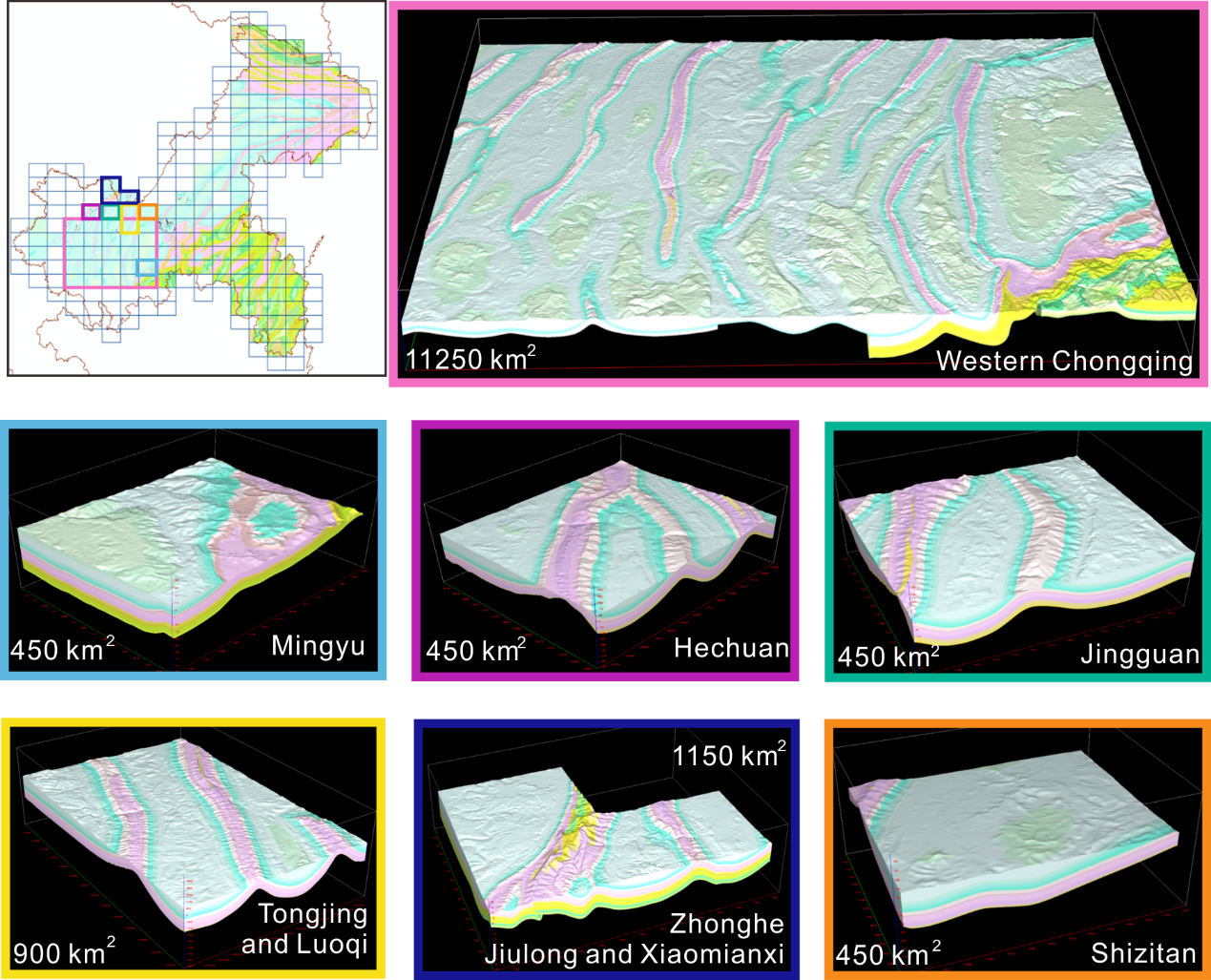
Most geological models currently used in metro construction are limited to narrow corridor zones along the metro line, with limited coverage. This "pipeline-style" model lacks the support of regional geological context, making it difficult to fully assess the regional impact of engineering activities on the surrounding environment (such as land subsidence caused by large-scale groundwater dewatering) or to comprehensively avoid geological risks originating from outside the line.
Urban 3D geological modeling advocates for the establishment of regional models covering entire cities or large areas. Within this framework, high-precision local models are then built for specific metro lines. The regional model provides a macro geological context and boundary conditions, enabling more accurate simulation of groundwater seepage fields and in-situ stress fields. This allows for more scientific prediction of the interaction between the metro project and the surrounding geological environment, achieving a strategic upgrade from "considering only the line" to "regional synergy."
Type: Dual Representation of Structure and Properties
An urban 3D geological model is not a single model but consists of two core types:
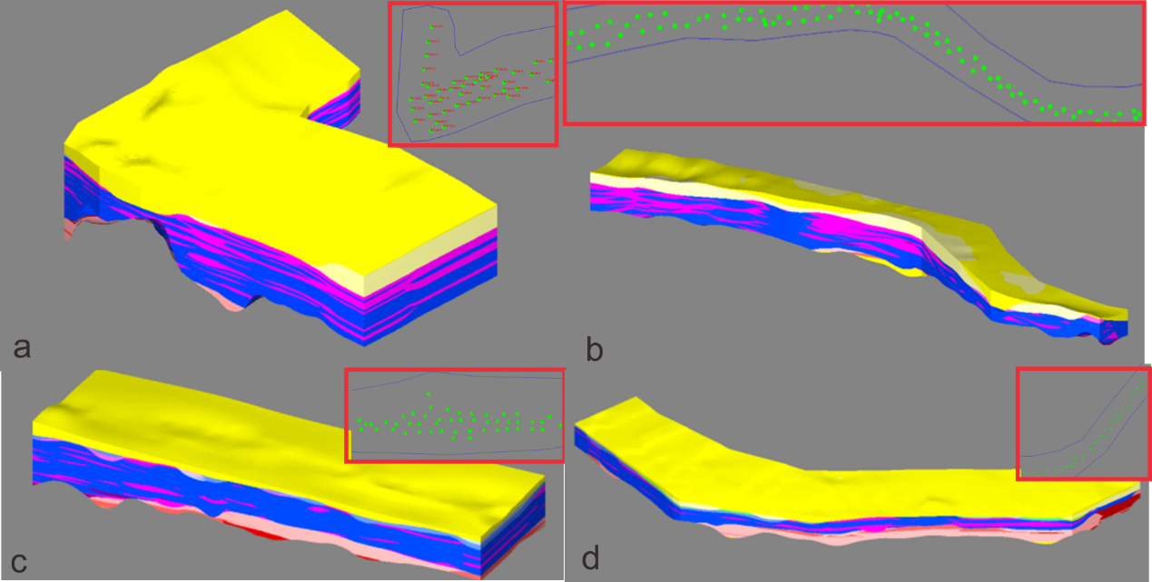
1.Structural (Tectonic) Model: This forms the basic skeleton of the model, used to precisely depict the spatial morphology, interface relationships, and structural features of geological bodies such as strata, rock masses, faults, fracture zones, and karst caves. It clearly displays interfaces between soil and rock layers, fluctuations of the bedrock surface, spatial locations of unfavorable geological bodies, etc. It serves as the primary basis for engineering site selection, longitudinal profile design, and construction method selection.
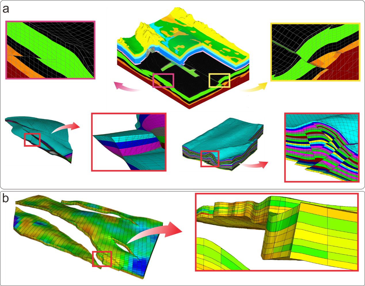
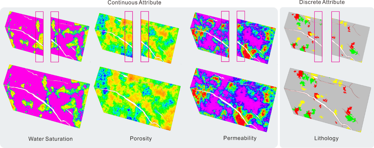
2.Property Model: Building upon the structural model, this assigns specific geotechnical physical and mechanical parameters to each 3D spatial unit, such as density, porosity, permeability coefficient, elastic modulus, cohesion, and internal friction angle. This transforms the geological model from a "nice-looking skeleton" into a "computable digital body," providing the data foundation for subsequent geomechanical analysis and numerical simulation.
Impact: Precise Control of Core Geological Factors
The core value of a 3D geological model lies in its ability to integrate with numerical simulation technology to quantitatively analyze the impact of geological conditions on the project, primarily focusing on the following aspects:
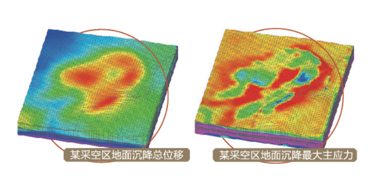
1. Geomechanical Analysis: Based on numerical models founded on high-precision geological models, calculations for slope stability, foundation pit excavation support, tunnel surrounding rock stability, etc., can be performed to optimize design schemes and assess construction safety.
2. In-Situ Stress Field Simulation: Simulating the distribution of regional in-situ stress, analyzing stress redistribution caused by tunnel excavation, predicting disaster risks such as rock bursts and large deformations, and providing key parameters for shield machine selection (cutterhead pressure settings) and support structure design.
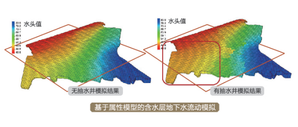
3.Seepage Field Simulation: Simulating the flow patterns of groundwater in three-dimensional space, accurately predicting water inflow during foundation pit or tunnel excavation, the extent of dewatering influence, and assessing the impact of construction dewatering on the settlement of surrounding buildings. This is an indispensable tool for controlling groundwater-related risks.
Application: Spanning the Entire Metro Lifecycle
The application of 3D geological models can span every stage of a metro project—design, construction, operation, and maintenance—which is the most direct manifestation of its importance.
1. Design Phase: Optimizing route alignment and burial depth to avoid unfavorable geological bodies; rationally locating stations and shaft positions; providing a reliable basis for construction method comparison and support design, thereby reducing engineering risks and costs at the source.
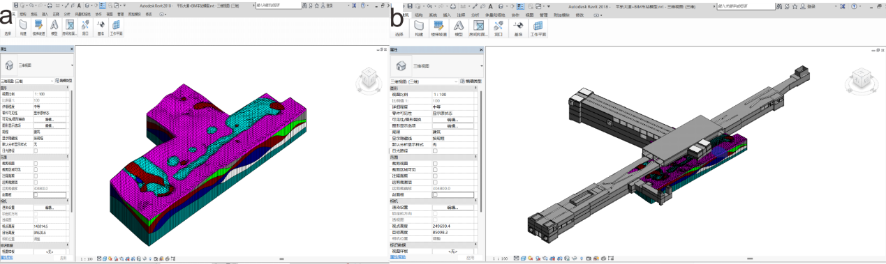
2. Construction Phase: Conducting dynamic risk forecasting to guide construction tunneling parameters; performing rapid back-analysis and cause investigation for sudden geological hazards (such as water inrushes and collapses), assisting in the formulation of emergency response plans; realizing digital management of the construction process (digital twin).
3. Operation and Maintenance Phase: As part of the "urban geological infrastructure," the model enables long-term monitoring of tunnel convergence, deformation, and settlement changes during operation. Comparing this data with model predictions facilitates safety warnings. It also provides a permanent, accurate geological database for future line extensions and station renovations.
Requirements: Ensuring Model Reliability and Usability
To build a high-quality 3D geological model that truly serves the engineering project, the following stringent requirements must be met:
1. Data Volume: Reliance on massive amounts of multi-source geological data, including boreholes, geophysical surveys, topography, remote sensing, and historical hazard data. The greater the quantity and precision of the data, the higher the model's reliability. Currently, most metro geological modeling relies on independently collected borehole data, neglecting data from other projects along the line (e.g., construction of surrounding structures), relevant geological surveys, remote sensing, and historical data. Subsurface geological bodies exhibit characteristics like anisotropy and heterogeneity. Therefore, the modeling process should collect as much data as possible, process it into modeling source data, define unified geological semantics, and construct a high-precision model.
2. Updates: As investigation deepens and construction exposes new information, newly acquired data must be continuously integrated into the model for verification and correction, making it infinitely approach the real geological conditions. The speed and frequency of updates need to match the development progress and scenario requirements.
3. Validation: The model must undergo rigorous validation. By comparing it with borehole data not used in modeling, geophysical detection results, or actual excavated faces, its predictive accuracy is assessed, and uncertainties are quantified.
4. Model Revision: During the modeling process, professional interpretation and intervention by geological engineers are crucial. Experts must use geological principles to judge the reasonableness of algorithm-generated results, ensuring the model aligns with geological understanding. However, direct editing of the model should be avoided. Model generation must comply with geological laws. If source data is incorrect, it must be corrected; if new constraint point data is available, it should be added to the source data. Then, relying on algorithms like geostatistics (e.g., Kriging interpolation) or machine learning, automatic interpolation of geological horizons and spatial prediction of property parameters should be performed to achieve efficient modeling.
5. Parallelism: The modeling process requires parallel collaboration among engineers from multiple disciplines, including geology, surveying, computer science, and geotechnical engineering. It is a typical interdisciplinary task. Distributed parallel modeling primarily addresses the needs of large-scale, high-precision modeling (where model precision and scale are limited by single-computer performance). Different professionals have varying understandings of the geological environment, so this process should be constrained. During parallel work, metadata should be generated, recording personnel actions, which data were modified, and implementing hierarchical responsibility management.
High-precision 3D geological modeling transforms traditionally dispersed, obscure geological information into a unified, intuitive, and analyzable three-dimensional digital body. It serves as the core infrastructure for metro projects to cope with complex underground environments and achieve precise design, intelligent construction, and smart operation and maintenance. This is not merely an upgrade of technical tools but also an innovation in management philosophy. It holds irreplaceable importance for ensuring metro project safety, controlling investment risks, and protecting the urban geological environment. Promoting its standardized and widespread application is an inevitable trend for the sustainable development of future urban underground space.